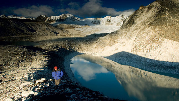
The Snowman Trek
This spectacular 28-day adventure in Bhutan begins with the 23-day Snowman trek into one of the country’s most remote valleys. This is probably one of the hardest high altitude treks, but an incredible experience for anyone who takes the challenge. Bhutan’s pristine landscape, wonderful people and fascinating Buddhist culture provide the ingredients for a memorable journey into one of the world’s most remote kingdoms.
The Snowman Trek is an extension of the beautiful Laya Gasa Trek, and leads from Laya into high altitudes of the Bhutanese Himalayas. Trekkers have to camp in altitudes above 5,000 m more than once, and depending on the seasonal temperatures, the camps are sometimes on snow. The Lonely Planet describes the Snowman Trek as one of the most difficult treks of the world. The best time for Snowman Trek is summer – unlike many other high altitude treks of Bhutan. Along with the trek you would be embarking on Cultural Tour where you would visit some of the key sight seeing places in Thimphu, Paro and Punakha.
Brief Description of Cities covered in this tour
Thimphu: Capital and the largest city of Bhutan - Only capital city in the world that does not have traffic lights - Main center of Commerce, Religion and Government in the country - Most modern city of Bhutan and has abundance of restaurants, internet cafes, nightclubs and shopping center. It is one of the few cities of Bhutan having ATM facilities.
Paro: Small town in the western part of Bhutan - Also home to Paro Airport, Bhutan’s only International Airport - The valley has many isolated small villages and is known for red rice - Also home to most of Bhutan’s oldest temples and monasteries.
Punakha and Wangdue: Punakha and Wangdue is located in the same valley. These two places are located within a distance of 13 km. Punakha was the capital of Bhutan and the seat of government until 1955 - The valley is fed by the Pho Chhu and the Mo Chhu rivers - It is one of very few places in Bhutan which offers Rafting facilities - It is the winter seat of the Je Khenpo (Chief Abbot) and the monk body at present.
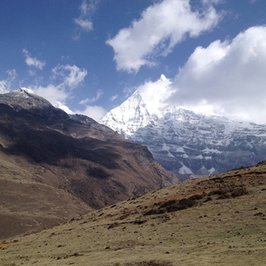
- Experience fabulous views of snow-capped mountains such as Mt. Jomolhari and Mt. Jichu Drake.
- Traverse beautiful landscapes from lush valleys and dense forests to high mountain passes.
- Camp overnight beneath some of Bhutan’s most impressive mountain peaks.
- Breathtaking view of the Himalayas, nomadic yak herders camp, exotic flaura & fauna.
- Visit old Monasteries and majestic fortresses
- Explore a capital city with no traffic lights.
- Feast on Ema Datsi and Red Rice, two of the most popular dishes of Bhutan
- First-hand experience of untouched Nature and unique Culture
- Experience the Sacred Spirituality and see the prayer flags fluttering in the wind.
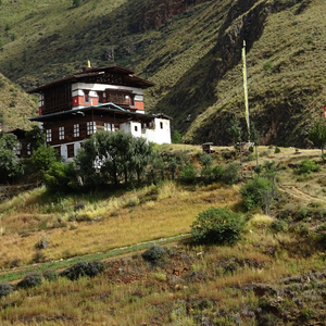
- Village houses and rural life
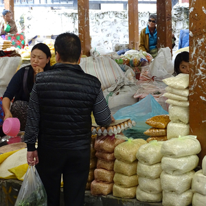
- Shop for Silks, Souvenirs and More
- Marvel at structures adorned with Phallus paintings.
- Hike through pine forests to visit “Tiger’s Nest”
- The must visit Dochula Pass and the Druk Wangyal Chhortens.
Day 1. Arrive at Paro:
Altitude of Paro 2,250 m
Your flight to Paro on a clear day, is marked with the panoramic views of the Himalayas including the Everest and other famous Peaks. The approach through the foothills and the landing (including few steep turns) at the tiny airstrip of Paro has been termed as adventurous by many travelers. After the completion of immigration formalities at the Paro Airport exit door, you will be received by your Bhutanese guide with traditional “Tashi Khadar”. Thereafter you are driven to your hotel and do your check in. In the Afternoon post lunch, visit
- Paro Rimpung Dzong, also known as Fortress of the heap of jewels, built during the time of Shabdrung Ngawang Namgyal in 1646.
- Ta Dzong, an ancient watch tower overlooking Rimpung Dzong built in 1951 now converted into national museum.
In the evening, explore the Paro Valley and town.
Meals – Breakfast, Lunch and Dinner; Overnight at the Hotel in Paro.
Day 2. Paro Sightseeing:
After breakfast, start your day with a hike to
- Taktsang Monastery (Tiger's nest), the abode of gods and monks situated at an altitude of 3100m on the Upper Paro Valley, Bhutan. As per the legend, Guru Padmasambhana (Guru Rinpoche), the tantrum mystic who brought Buddhism to Bhutan, came in the form of Dorje Droloe riding a flying tigress to subdue the demon that was obstructing the spread of Buddhism in the Himalayas.
After the completion of the hike, you would be served picnic Lunch among the woods. After lunch, visit
- Kyichu Lhakhang, one of the oldest monasteries in Bhutan built in the 7th century by the Tibetan Emperor Songtsen Gampo.
Then drive to Shana (Starting point of trek) through farm roads.
Meals – Breakfast, Lunch and Dinner; Overnight in Camp. Camp Altitude 2,820 m.
Day 3. Shana - Thangthangka: (Start of the Trek):
Camp Altitude 3,610 m; Distance 21 Kms; Time 7 hrs - 8 hrs; Ascent 770 m; Descent 10 m
The trail follows the river through a heavily forested area with a few isolated farmhouses. It narrows and closes in and the trail winds up and down along the drainage. We pass a junction enroute, where another path leads north over the Tremo La to Tibet. Camp is in a meadow with a stone shelter.
Meals – Breakfast, Lunch and Dinner. Overnight at the Camp.
Day 4. Thangthangka - Jangothang:
Camp Altitude 4,115 m; Distance 15 Kms; Time 5 hrs - 6 hrs; Ascent 480 m
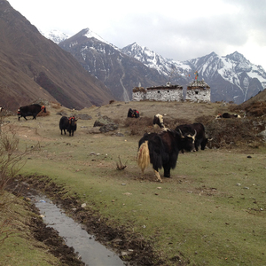
In the morning after passing a small army post, the trail slowly leaves the forest line and gradually climbs into a beautiful valley, passing Tegethang, a winter home of yak herdsmen. Lunch will be served in one of these huts. Lots of yaks will be seen today before we arrive at the Jhomolhari Base Camp (4,115 m). High mountains overlook the camp and visible nearby are the ruins of an old fortress used to guard Bhutan against Tibetan invasions.
Meals – Breakfast, Lunch and Dinner. Overnight at the Camp.
Day 5. Jangothang:
Rest Day
Today you will stay at the camp site. Jangothang is a perfect environment for your acclimatization. There are good chances that one may spot some blue sheep on the upper slopes of the valley. You also have a chance to walk up to the Jhomolhari glacier or to the Tsho Phu lakes on the opposite direction.
Meals – Breakfast, Lunch and Dinner. Overnight at the Camp.
Day 6. Jangothang - Lingshi:
Camp Altitude is 4,000 m; Distance 20 Km; Walking Time 7 hrs - 8 hrs; Ascent 840 m; Descent 870 m
The trail follows the stream for half an hour and crosses the bridge to the right side. Start the climb up to the first ridge with a breathtaking view of Jomolhari, Jichu Drake and Tserim Gang. Then walk towards the valley, almost flat for a while, until the climb to the Nyeley la pass at an altitude of 4,700 m. After the pass it’s a gradual descent to the Lingshi camp, enjoying the panorama view of the peaks and Lingshi Dzong.
Meals – Breakfast, Lunch and Dinner. Overnight at the Camp.
Day 7. Lingshi - Chebisa:
Camp Altitude is 3,850 m; Distance 14Kms; Walking Time 5 hrs - 6 hrs; Ascent 280 m; Descent 410 m
Walk past the Lingshi Dzong, perched on the hilltop with a commanding view of green hill, the Winding River and magnificent peaks. This is a very easy day and a pleasant walk, through villages and yak herder’s camps. Lunch will be at scenic Goyuna village. After lunch, a short walk will reach you to Chebisa village.
Meals – Breakfast, Lunch and Dinner. Overnight at the Camp.
Day 8. Chebisa - Shomuthang:
Camp Altitude is 3,993 m; Distance 17Kms; Walking Time 7 hrs - 8 hrs; Ascent 890 m; Descent 540 m
Today begins with a stiff climb up a ridge to Gubula pass at an altitude of 4,500 m, taking nearly 4 hours to the top. After the pass descend to a lunch spot, through rhododendron bushes. Afternoon continue along the up and down path, after crossing the stream, through rhododendron forests and yak herder’s camps. You may see herds of Blue sheep now and then.
Meals – Breakfast, Lunch and Dinner. Overnight at the Camp.
Day 9. Shomuthang - Robluthang:
Camp Altitude is 4,400 m; Distance 22 Kms; Walking Time 8 hrs - 9 hrs; Ascent 700 m; Descent 760 m
The trek starts with a climb to Jari la pass at the altitude of 4,600 m. Then descend to Tsharijathang valley, the summer residence of the rare Himalayan Takin (national animal of Bhutan). From here we may have to cross the stream and get wet, as most of the time the foot bridge is washed away, after crossing the stream towards the left the trail ascends till you reach Robluthang.
Meals – Breakfast, Lunch and Dinner. Overnight at the Camp.
Day 10. Robluthang - Lemithang:
Camp Altitude is 4,100 m; Distance 14 Kms; Walking Time 7 hrs - 8 hrs; Ascent 850 m; Descent 870 m
A long climb up to the Shinje La Pass (altitude 4,900 m). The views of the mountains from the pass are breathtaking. After the pass descend to Lemithang. The path is quit narrow and you may have to cross the stream and get wet again. The last part of the trek is very interesting, with the view of Mount Gangche Ta peak.
Meals – Breakfast, Lunch and Dinner. Overnight at the Camp.
Day 11. Lemithang - Laya:
Camp Altitude is 3,800 m, Distance 10 Kms, Walking Time 5 hrs - 6 hrs; Ascent 60 m; Descent 340 m
In the morning you wake up with a superb view of Gangche Ta peak in front of you. The walk to Laya is very pleasant with wonderful views. You will pass through a damp forest, filled with moss and singing birds. Arrive at Laya village, the second highest settlement in the country, at an altitude of 3,800 m.
Meals – Breakfast, Lunch and Dinner. Overnight at the Camp.
Day 12. Laya:
Day of Rest
We’ll pause for a day of rest in Laya with the opportunity to meet the local people and to visit nearby sights. This picturesque village is surrounded by snowy mountain peaks. It’s possible to visit the local school here as well as the community’s Dzong. This will also be a good day for a tent shower and to do some laundry.
Meals – Breakfast, Lunch and Dinner. Overnight at the Camp.
Day 13. Laya - Rhodophu:
Camp Altitude 4,350 m; Distance 17 Kms; Walking Time 8 hrs - 9 hrs; Ascent 1,030 m; Descent 750 m
This route follows the river downstream for a while and heads east to reach at Rhodophu. Certain sections of the trail will be washed away by frequent landslides so we’ll have to negotiate the trail over huge boulders and narrow paths. Rhodophu is a small, narrow and rocky valley used by the people of Laya to migrate with their Yaks.
Meals – Breakfast, Lunch and Dinner. Overnight at the Camp.
Day 14. Rodophu - Narethang:
Camp Altitude 4,900 m; Distance 10 Kms; Walking Time - 6 hrs - 7 hrs; Ascent 740 m
The trail follows the river through rhododendron and shrubs. Blue sheep can be frequently seen in this part of the trek route. This is also the snow leopard territory – an elusive animal of Himalayas. The camp is at Narethang (4,900 m) below the Gangla Karchung Peak.
Meals – Breakfast, Lunch and Dinner. Overnight at the Camp.
Day 15. Narethang - Tarina:
Camp Altitude - 3,900 m; Distance 25 Kms; Walking Time 9 hrs - 10 hrs; Ascent 270 m; Descent 1,200 m
We cross the Gangla Karchung La (Pass) (5,120 m). From here the mountain views are excellent on the northern horizon. To name a few: Kang Bum (6,526 m), Teri Gang (7,300 m) Jejekangphu Gang (7,100 m). Overnight in camp in Tarina.
Meals – Breakfast, Lunch and Dinner. Overnight at the Camp.
Day 16. Tarina - Woche:
Camp Altitude 3,800 m; Distance 12 Kms; Walking Time 6 hrs - 7 hrs; Ascent 270 m; Descent 330 m
The day is much easier as the path follows the river down valley. Lunch at the lowest point (3,500 m). After lunch climb up about 300 m to the village of Woche.
Meals – Breakfast, Lunch and Dinner. Overnight at the Camp.
Day 17. Woche - Lhedi:
Camp Altitude 3,650 m; Distance 15 Kms; Walking Time 7 hrs - 8 Hrs; Ascent 980 m; Descent 1,190 m
The Trek starts through juniper and fir forests and then through rhododendron bushes. We climb up to Keche la pass (4,480 m) where one can have a great view of the mountains. After the pass, descend to the river walking through the village with stunning views of Table Mountain and others. Follow the river, one of the main source of Phochu, till Lhedi village.
Meals – Breakfast, Lunch and Dinner. Overnight at the Camp.
Day 18. Lhedi - Thanza:
Camp Altitude 4,000 m; Distance 15 Kms; Walking Time 7 hrs - 8 hrs; Ascent 450 m
The trek continues following the river, rising gradually to Choejong village. he valley was washed away by the glacial flood of 1994 forming a typical glacial landscape. After lunch visit the Choejong Dzong and continue towards the wide valley. Cross the bridge to reach Thanza camp.
Meals – Breakfast, Lunch and Dinner. Overnight at the Camp.
Day 19. Thanza - Day of Rest :
Today is another well-deserved rest day where we’ll be able to explore the village and visit with the people of Thanza. We’ll enjoy an excellent view of Table Mountain while also being able to catch up, once again, on laundry and showering.
Meals – Breakfast, Lunch and Dinner. Overnight at the Camp.
Day 20. Thanza - Tshochena:
Camp Altitude 3,850 m; Distance 20 Kms; Walking Time 8 hrs - 9 hrs; Ascent 750 m
Today is a long trekking day. We should start early as possible. The trek continues through the mountains. One comes across blue lakes and yak herder’s camps to arrive at the Tshochechen camp at an altitude of 3,850 m.
Meals – Breakfast, Lunch and Dinner. Overnight at the Camp.
Day 21. Tshochena - Jichu Dramo:
Camp Altitude 5,050 m; Distance 14 Kms; Walking Time 5 hrs - 6 hrs; Ascent 230 m; Descent 150 m
The trail follows the shore of a lake before climbing a ridge at 5,100 m. On the top, you are surrounded by snowy peaks. Far below you can see the Pho Chhu descending down towards Punakha. The trek continues through mountains. Overnight in camp in Jichu Dramo (5,050 m), a small pasture on the east side of the valley.
Meals – Breakfast, Lunch and Dinner. Overnight at the Camp.
Day 22. Jichu Dramo - Chukarpo:
Camp Altitude 4,600 m; Distance 18 Kms; Walking Time 6 hrs - 7 hrs; Ascent 320 m; Descent 730 m
The trail is gradual with ups and downs between the snow- capped peaks. The trail climbs to Rinchen Zoe la (5,320 m). Then continue through breath taking scenery. After a couple of hours we reach Chukarpo (4,600 m).
Meals – Breakfast, Lunch and Dinner. Overnight at the Camp.
Day 23. Chhu Karpo - Thampe Tsho:
Camp Altitude 4,300 m; Distance 18 Kms; Walking Time 6 hrs - 7 hrs; Ascent 400 m; Descent 700 m
The trail continues to descend along the right bank of the river until it reaches a yak pasture at Gala Pang Chhu (4,010 m). From here the path climbs quite steeply through Junipers and Silver Firs towards Thampe Tsho. The path follows a stream to the beautiful lake, surrounded by steep mountain walls. Overnight in Thampe Tsho (4,300 m).
Meals – Breakfast, Lunch and Dinner. Overnight at the Camp.
Day 24. Thampe Tsho - Maurothang:
Camp Altitude 3,610 m. Distance 14 Kms, Walking Time 5 hrs - 6 hrs; Ascent 330 m; Descent 1,020 m
From the camp the trail climbs steeply to Thampe la at 4,600 m. Along the way, you may see blue sheep on the high slopes above the trail. The path descends to Om Tsho. It is said that Pema Lingpa found a number of Terma here. You will then pass a water fall. From the second lake the path descends steeply to the head waters of the Nikka Chhu. Then the path follows through a mixed forest to Maurothang (3610m).
Meals – Breakfast, Lunch and Dinner. Overnight at the Camp.
Day 25. Maurothang Sephu - Punakha: (End of trek):
Distance 18 Kms, Walking Time 6 hrs - 7 hrs; Descent 990 m
After walking for about four hours you will reach a large grassy area overlooking the village of Sephu. You will find our vehicle waiting for you. Drive to Punakha.
Meals – Breakfast, Lunch and Dinner. Overnight at the Hotel in Punakha.
Day 26. Punakha Sightseeing - Thimphu:
Altitude of Thimphu 2,350 m
After breakfast, visit the
- Punakha Dzong, built in 1637 by Shabdrung Ngawang Namgyal. For many years until the time of the second King, it served as the seat of the Government. It is still the winter residence of Je-Khenpo (The Chief Abbot of the Central Monastic Body of Bhutan).
- Chhimi Lhakhang, a famous Temple, which is also known as “The Temple of Fertility” built by Lama Drukpa Kuenley.
After lunch, drive to Thimphu. Enroute halt at
- Dochula Pass, lies at an elevation of 3,150 m and is a great place to view the higher Himalayas. The landmarks around the pass includes 108 Druk Wangyal Stupas built under the patronage of Queen Ashi Dorji Wangmo Wangchuk
After arrival in Thimphu, complete check in formalities. Later visit
- Tashichhodzong, or ‘the fortress of the glorious religion’. Initially erected in 1641 by Shabdrung Ngawang Namgyal, it was rebuilt in the 1960s during the reign of Bhutan’s third king in the traditional style, without plans or nails. It houses some ministries, His Majesty’s secretariat, and the central monk body and opens after 5 PM.
Meals – Breakfast, Lunch and Dinner. Overnight at the Hotel in Thimphu.
Day 27. Thimphu Sightseeing - Paro:
Altitude of Paro 2,250 m
Today you would be driven in and around Thimphu covering key places of interest. After breakfast you would visit
- Kuensel Phodrang, the gigantic Buddha Dordenma Statue located atop a hill in Kuensel Phodrang Nature Park.
- National Memorial Chhorten, a Stupa built in 1974 to honor the third Druk Gyalpo, Jigme Dorji Wangchuck. Every morning till night old people and young people circumambulate the Chhorten.
- Zorig Chusom, Premier institute of traditional arts and crafts in Thimphu built to preserve “thirteen arts and crafts of Bhutan”.
- Folk Heritage, traditional house giving an insight to the Bhutanese lifestyle, and artifacts from the rural households
Thereafter you would be taken to a local restaurant for lunch. In the afternoon you would be taken to
- Sangaygang View Point, also known as BBS Tower offering panoramic view of Thimphu Town situated at an elevation of 2,685 m.
- Changangkha Monastery, popular fortress like temple perched on a ridge above Central Thimphu built in 15th Century by Lama Phajo Drugom Zhipo.
- Takin Preserve Centre, see Takin (National animal of Bhutan) It is a unique combination of Goat and an Antelope
In the evening, drive to Paro which is one and half hours away at a distance of around 56 Kms.
Meals – Breakfast, Lunch and Dinner. Overnight at the Hotel in Paro.
Day 28. Departure:
Today we will bid farewell to this beautiful country and take an early flight back. We hope by now you must have made some good friends and also have taken photographs and beautiful memories of Bhutan. We certainly hope of serving you again on your next visit to this great country or the Last Shangri-La. Tashi Delek.


